Désolé pour le retard dans mon blog, j'ai profiter un peu plus du voyage ces dernier temps, je vais tout mettre à jour dès que je vais avoir 2 minutes (more like 10-15 hours). Nous sommes à Titusville FL.
Sorry for the delays on my blog, I took more time to enjoy my trip lately, I will update everything as soon as I have 2 minutes (more like 10-15 hours). We are in TItusville FL,
lundi 22 novembre 2010
vendredi 19 novembre 2010
10-11 novembre 2010, 30 miles au large
FR:
Ce matin, nous quittons vers 7h00 en direction de l’océan. Je ne me suis pas cassé la tête pour les waypoints, comme la météo est favorable, j’ai tiré une ligne droite entre Charleston et St-Mary’s entrance, ce qui devrait nous mener à 25-30 miles nautiques au large (le Gulf Stream est beaucoup plus au large à ce niveau). Comme il s’agit d’une course de 172 miles nautiques d’un ancrage à l’autre, nous devons conserver une vitesse moyenne d’au moins 5 nœuds si nous voulons arriver avant 17h et de 6 nœuds pour arriver avant 12h.
Nous avons un vent léger dans le dos, on se met donc en mode motorsailor, toutes voiles dehors, avec le moteur qui tourne à 1600 tours. On réussit ainsi à garder une vitesse moyenne supérieure à 6 nœuds, en utilisant très peu de diesel. On se relie toute la journée et toute la nuit toutes les 3 heures. Les quarts sont éprouvants, nous n’avons pas de régulateur d’allure ou de pilote automatique, nous devons donc rester concentrés. Les étoiles à 30 miles au large sont vraiment impressionnantes.
Vers 10h, nous entamons notre entrée dans l’inlet de St-Mary’s avec de bonnes vagues poussées par une tempête au large des Bermudes. L’entrée se fait en un clin d’œil, le vent et le courant sont de notre côté, on file à plus de 8 nœuds vers l’intérieur. On s’ancre vers 11h derrière Cumberland Island et on se paye une bonne sieste.
En fin de journée, Alraso nous rejoint, les fenêtres météo n’étaient pas bonnes pour St-Martin, ils ont décidé de passer aux Bahamas avec nous. Nous sommes très heureux de les retrouver. On recommence les 5 @ 7 ce soir !
Notre position en fin de journée : 30°46.063N 081°28.297W
EN:
This morning, we leave at around 7 am in direction of the ocean. The waypoints planning was pretty much straight forward, as the weather is ideal, I simply drew a straight line from Charleston to St-Mary’s entrance, which should take us about 25-30 nautical miles offshore (the Gulf Stream is a lot further here). As it is as 172 miles run, from anchorage to anchorage, we need to keep our average speed above 5 knots if we want to make it before 5 pm and above 6 knots to arrive before noon.
We have a light wind pushing us in the back, so we turn into motorsailing mode, all sails out, with the engine revving at 1600 rpm. This way we are able to keep our speed above 6 knots without using too much diesel. We replace each other behind the wheel all day and all night every 3 hours. The shifts are nerve wracking, we don’t have any form of autopilot, so it needs a lot of concentration. The stars 30 miles offshore are just amazing.
At around 10 am, we are starting our entry into the St-Mary’s inlet, with a good swell produced by a storm off the Bermudas. We clear the inlet in a blast, the wind and the current are with us, we travel at over 8 knots towards the inside. We anchor behind Cumberland Island at around 11 am and we go for a well deserved nap.
At the end of the day, Alraso catches up with us, the weather window to cross to St-Martin didn’t materialize, so they decided to cross with us to the Bahamas. We are very happy to see them again. Happy hours back on the schedule starting tonight !
Our position at the end of the day : 30°46.063N 081°28.297W


9 novembre 2010, USS Yorktown
FR:
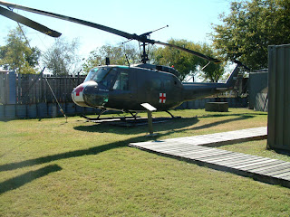
Aujourd’hui, petite journée tout ce qui a des plus ordinaires, hihi. En avant-midi, on fait un déjeuner continental collectif sur Peace IV, qui nous prête 100 pieds de chaine pour nous dépanner, ce qui est extrêmement apprécié. Ensuite, on se dirige à terre en short et en t-shirt! Le beau temps nous a finalement rejoints. On profite du reste de la matinée pour visiter un porte-avion et un sous-marin, rien de moins.
En après-midi, on fait une petite épicerie histoire de faire le plein de denrées périssables. On retourne au bateau quelques minutes avant le coucher du soleil, juste à temps pour éviter de se faire dévorer par les No-See-Ums. La connexion internet est très instable, je réussi tout de même à prendre la météo, qui semble idéale pour qu’on fasse une sortie en mer direction la Floride. On se couche donc tôt.
EN:
Today, little day, nothing special, hihi. In the morning, we throw in a collective continental breakfast with Peace IV, who very kindly lend us 100 foot of chain, which is extremely appreciated. After, we head to shore wearing shorts and t-shirts! The nice weather has finally caught up with us. We enjoy the rest of the morning to visit an airplane carrier and a sub, nothing less.
In the afternoon, we go grocery shopping; we need perishable goods. We return to the boat with only minutes to spare before the sun goes down, just in time to avoid being eaten alive by the No-See-Ums. The internet connection is very weak, but I still manage to get an update on the weather, which looks ideal for a passage offshore tomorrow in direction of the state of Florida. We go to bed early.


8 novembre 2010, De la chaine !
FR:
Décidément, 35 pieds de chaine 5/16" et 300 pieds de câble 5/8" ça ne vaut rien ici où le courant s’amuse avec vent. Ce matin, le câble d’ancre est bien coincé dans le gouvernail, il nous faut une bonne heure pour le déprendre (on envoie une gaffe par le fond en même temps). Prochain arrêt, on achète au moins 200 pieds de chaine. En attendant, on utilisera les ancres champignons pour garder le câble bien au fond.
Les vents ne sont pas adéquats pour une sortie en mer, on parcourt donc les 59 miles terrestres qui nous séparent de Charleston par l’ICW. Vers 14h la température finit par remonter, ce qui nous permet d’enlever nom manteaux et nos combines. On fait un petit arrêt à la marina pour faire le plein, 3.30$/gal, c’est très dispendieux surtout qu’on a besoin de 44 gallons.
On s’ancre dans un maigre 5.5 pieds d’eau et il reste 1 pied à descente avant la marée basse, on va possiblement s’asseoir dans le fond si des zones sont moins profondes. Demain, on fait l’épicerie, on parle de plus en plus de faire une bonne sortie en mer pour rejoindre la Floride à partir d’ici.
Notre position en fin de journée : 32°47.072N 079°52.992W
EN:
Apparently, 35 feet of 5/16" chain and 300 feet of 5/8" is worth nothing here where the wind like to play with the current. This morning, the anchor cable is still stuck in the rudder, it takes us a good hour to set it free (we send one of our gaff down the bottom at the same time). Next stop, we buy at least 200 feet of chain. Until then, we will be using the mushroom anchors to keep the rode down the bottom.
The winds are not adequate to go out at sea, we travel the 59 statute miles that are between us and Charleston through the ICW. At round 2 pm, the temperature finally gets warmer, we can therefore get rid of our coats and base layers. We quickly stop at the marina for some diesel, $3.30/gal, that is expensive and we need 44 gallons.
We anchor in 5.5 feet of water and it will go down at least a feet before the tides is low, so we will possibly sit on the bottom if there are some shallower areas. Tomorrow, grocery shopping, as we are thinking more and more about going offshore to skip Georgia and go directly to Florida from here.
Our position at the end of the day : 32°47.072N 079°52.992W


jeudi 18 novembre 2010
7 novembre 2010, Row Row Row your boat...
FR:
Ce matin, nous quittons Calabash Creek avec joie, nous allons rallier Georgetown par la mer. Pendant un bon trois heures, nous filons à 7 nœuds avec un vent de travers avant que notre course change et qu’on se retrouve vent arrière et que notre vitesse chute à 4 nœuds. On doit partir le moteur si l’on veut arriver avant la noirceur. La bonne nouvelle c’est qu’avec le moteur à très bas régime, on réussit à ramener le vent apparent de travers et on file maintenant à 8 nœuds ce qui est impressionnant.
L’inlet de Georgetown est plutôt mouvementée. Le vent est monté à 30 nœuds et la marée est sortante. Il nous faut une bonne heure et beaucoup d’huile de coude pour la franchir.
On s’ancre dans Winyah Bay et on va sur Peace IV qui nous a invités pour le souper (excellent d’ailleurs). Lorsque l’on ressort, la lune n’est pas levée et malgré les milliards d’étoiles, il fait très noir. Un seul problème, un GROS problème, notre voilier n’est plus visible et n’est définitivement plus où on l’avait ancré. On finit par le repérer avec un projecteur, il a dérive et dérive probablement toujours, il est à plus d’un demi-mile d’où il devrait être. On embarque dans l’annexe et on se met à ramer en malade (nous n’avions pas installé le hors-bord, nous étions trop près pour que ça vaille la peine). On le rattrape, heureusement il est resté en plein milieu de la zone plus profonde. Le câble d’ancre semble s’être pris dans le safran à cause de l’action du fort courant et du vent, ce qui a fini par arracher l’ancre. On réussit à ce ré ancré, mais nous ne dormirons que d’une oreille ce soir.
Notre position en fin de journée : 33°15.534N 079°14.727W
EN :
This morning, we leave Calabash Creek with joy to rally Georgetown out on the sea. During a good three hours, we go forward at 7 knots with the wind on our beam before our heading changes and we end up downwind at a slower 4 knots. We need to start the engine in order to get there before dark. The good news is that with just a little help of the engine, we bring the apparent wind back on our beam and are now doing close to 8 knots which is impressive.
The inlet at Georgetown is somewhat bouncy. The wind has picked up and is now blowing near 30 knots and the tide is going out. It takes us a good hour and a lot of sweat to get in.
We anchor in Winyah Bay and we go aboard Peace IV who invited us for diner (excellent btw). When we come out of Peace after diner, the moon is not up and even with the billions stars, it’s pitch dark. Just one problem, a BIG problem, our sailboat is nowhere to be seen, it’s obviously not where we anchored it. We finally manage to find it using a searchlight; it has dragged and it’s probably still dragging. It’s now more than half a mile from where it should be. We jump into the dinghy and se start rowing like maniacs (since we were only here for one night and Peace was so close, we didn’t bother to put the outboard on). We finally catch up with Mathurin 2. Happily it stayed right in the middle of the deeper waters. The anchor cable seems to have gotten stuck in the rudder with the action of the wind and current, which in the end ripped the anchor. We manage to reset our anchor, but we will only sleep on one ear tonight.
Our position at the end of the day : 33°15.534N 079°14.727W


6 novembre 2010, Le cauchemard
FR:
Aujourd’hui, nous faisons une partie du trajet à l’intérieur de l’Intracostale. En effet, nous ne voulons pas contourner le Frying Pan Shoal, qui nous demanderait de sortir très loin en mer dans une région peu clémente. De plus, le trajet à l’extérieur est de 57 miles alors que celui en dedans est de seulement 21 miles.
En après-midi, nous arrivons à un pontoon bridge qui n’est pas en mesure d’ouvrir, la marée est exceptionnellement basse et il touche le fond. Il faut attendre une bonne heure que la marée remonte pour qu’il puisse finalement ouvrir. Heureusement, ce ponton ne sera pas dans un problème à notre retour, il sera mis au rancart dans 2 semaines.
En soirée, nous entrons dans Calabash Creek pour nous ancrer. Erreur ! Cet endroit est un cauchemar, peu importe ce que peut vous indiquer votre Skipper Bob. Très peu d’eau, un ensablement très important dans l’entrée (nous avons vu 7 bateaux s’y échouer), même nous avec nos 4 pieds de tirant d’eau on touche à 2 reprise. De plus, il y de la place pour environ 3 bateaux et nous sommes 15. À sa il faut ajouter un fond qui ne veut rien savoir de votre ancre (peu importe l’ancre), et un joyeux mélange de courant et de vent. On réussi finalement à s’ancrer de façon acceptable après 7 tentatives, pour se faire crier des bêtises par des pêcheurs saouls qui nous trouvent trop près du chenal. L’interrompu se ramasse à l’épaule d’un autre bateau après que le fond ait rejeté son ancre une plus de 15 fois. Deux bateaux ont tout simplement quitté les lieux, préférant rejoindre le prochain ancrage qui se trouve à plus de 20 miles de là de nuit.
Notre position en fin de journée : 33°52.551N 078°34.339W
EN:
Today, we are travelling along the ICW. We don’t want to go around the Frying Pan Shoal, which would require that we go far offshore in an less than friendly area. Furthermore, the outside trip is 57 nautical miles the one on the inside is only 21.
In the afternoon, we arrive at a pontoon bridge that is not able to open, the tide is extremely low and so it’s hard aground. We have to wait a good hour for the tide to come in so that it can finally open. Happily, this pontoon bridge won’t be an issue on our way back, it will be put out of service in just two week thanks to new a high clearance bridge.
In the evening, we enter Calabash Creek to anchor. Big Mistake ! This place is a real nightmare whatever Skipper Bob might think of it. There’s little to no water, the entrance is basically shoaled across (we saw 7 boats run aground there), even us with our 4 feet draft we touched the bottom twice. Even worst, there is enough space for about 3 boats and we are 15. To that, you have to add a bottom allergic to anchors (all of them) and a very interesting mix of wind and current. We finally get our anchor to set after 7 attempts, to be shouted after by some drunk fisherman who thinks we are too close to the channel. The Interrompu ends up rafted to another boat after 15 unsuccessful attempts. At least 2 boats simply left preferring to continue along the ICW in the dark (I would not recommend that) to get to the next anchorage 20 miles away.
Our position at the end of the day : 33°52.551N 078°34.339W


mercredi 17 novembre 2010
5 novembre 2010, It's a chopper... It's a plane
FR:
Ce matin, réveil à 5h pour quitter Beaufort dans le noir en direction de Wrightsville NC (Masonboro inlet). Une petite heure après notre départ le soleil finit par se pointer le bout du nez ce qui nous permet d’aller monter les voiles (nous avions oublié d’installer nos lignes de vie). Nous sommes au près très serré, il nous faudra l’aide du moteur toute la journée si on veut arriver avant que le soleil se couche.
En après midi, deux avions hélicoptères (V-22 Osprey) nous survolent. Ce sont des engins vraiment impressionnants, on croirait qu’ils sont tout droit sortis de Terminator. Deux miles nautiques avant l’inlet, la poulie de la pompe à l’eau débarque. Une réparation somme toute rapide qui ne nous occasionne pas de retard. Dans l’inlet, on a le droit à tout un spectacle; des dizaines de dauphins chassent juste en avant de notre bateau.
En soirée, on prend un verre avec l’Interrompu, un couple de la Baie que nous avions rencontré à Elizabeth City. On finit la soirée avec notre 2e changement d’huile depuis le début du voyage. Nous sommes à 170 heures de moteur depuis notre départ.
Notre position en fin de journée : 34°12.458N 077°47.926W
EN:
This morning, our alarm clock is set at 5h am; we will leave Beaufort in the dark in direction of Wrightsville NC (Masonboro inlet). About an hour after our departure, the sun finally comes up, which allows us to raise the sails (we had forgotten to install our lifelines). We are heading very close to the wind, we will need the help of our engine if we want to make it in daylight.
In the afternoon, two chopper planes (V-22 Osprey) fly over us. These machines are very impressive, they look like they came straight out of Terminator. Two nautical miles before the inlet, the water pump pulley falls down from the shaft. It’s a fairly quick fix that doesn’t cause any delay. In the inlet, we are welcomed by a handful of dolphins hunting just in front of our boat.
In the evening, we go for a drink on Interrompu, some very nice people from La Baie we met in Elizabeth City. We end the night with our second oil change since the beginning of this trip. We have put 170 hours on the engine since we left so far.
Our position at the end of the day : 34°12.458N 077°47.926W


Inscription à :
Articles (Atom)